On April 28, 2009, we finally were done with stuff in ABC’s and found a weather window to go the 500nm to Cartagena, Colombia. Planning for this was abit scary as can be a rough passage (some say the 5th worst in world). We arrived in Cartagena in late afternoon Thursday, May 5th. It was a good passage with mostly sailing and motor/sailing. Below is a brief passage log of this journey. We hope this doesn’t bore some of you but good for our historic purposes.
We left Aruba around 6am to first anchorage of this journey – Monjes del Sur, Venezuela (12.21.65N, 070.55.00W) about 50nm, (small islands about 40nm from mainland Venezuela). E 15-20 winds, 4-6′ broad/beam seas so abit rolly broad reaching with full 135′ genoa, around 6.5knots with wind vane self steering “Pierre” doing wonderful, so batteries are happy. We left with Wind Dancer (Sue & Lenny Barrett – Ohio), Pearson 419.
We tacked broad reaching (as better than running dead down wind) the entire day and arrived around 4pm at Monjes del Sur. There are 2 islands (about 200′ tall) that the Venez Navy (Guardia Costa) connected with rock from the islands. This creates a safe harbor with the E/NE/SE prevailing winds. They hail any passing ship with intentions and manage a lighthouse, etc. They didn’t hail on VHF so I hailed them and asked for permission to stop for the night and if the rope was in service. This rope is tied between the 2 islands with some mooring lines attached such that possibly 6 sailboats could tie up but would need fenders. The cruiser made guide of ABC’s to Cartagena, Colombia and onto San Blas, Panama (ONLY guide available) said that they have had up to 36 fishing boats tied to this creating a boat bridge between the islands. They told me that there are 30 men that maintain this station (rotating every month) which is hard to believe as doesn’t appear to have enough sleeping quarters. Upon arrival 2 Spanish speaki6-ng junior staff (maybe 19 yrs old) asked to have us pick them up for check in and boat inspection. Usually that means they want to look around and get a small gift. They were very polite and official. Just before dark, 2 large Venez fishing boats showed up with one towing the other. We were ready with fenders and concerned that we may swing into them. They were very graceful maneuvering the towed boat to the cement wall, which is right next to us. Our next thought was how safe are we, as we know that the Guardia can sometimes be involved with theft. So we locked ourselves in when we went to bed.
So at 3am the following morning, we depart for 80nm to Cabo De La Vela, on mainland Colombia (12.14.00N, 072.10.00W) to overnight/anchor. Light E winds initially for 3 hours so motored making water but then E 15-20 winds broad reaching, 3-4′ broad/beam seas so abit rolly with full 135′ genoa, making around 7 knots due to the 1-1.5knot current assisting us.
We arrived in Cabo de la Vela around 4:45pm. The coast of Colombia was desert like and VERY pretty with Sierra de Capinterro red/grey sandy hills. Cabo de la Vela means “Cape Sail” so as we approached these hills we saw cargo loading ports and windmill farms. We decided that this may be a hint so we rolled in most of the genoa. As we rounded the cape toward our anchorage the winds increased immediately to 35kn so we rushed to roll in the rest and gave our little motor a work out. It’s a rush to get the anchor set in these conditions. We saw people and goats climbing the hills to watch the sunset and fisherman in small boats. Another interesting adventure with pretty views.
The next morning we depart at 0930am for the 120nm 24 hour overnight passage to 5 Bays (11.19.23N, 074.03.00W) with winds that are supposed to be E/NE 15 with isolated squalls.
We arrived Sunday at 10:30am in 5 Bays-Bahia Guayraca(11.19.23N, 074.03.00W), Colombia. We again broad reached with winds that filled in from E/NE 10-25 and seas built to 6-9′ so again rolly but tolerable until 6am when winds died with 18nm to go we turned on the “iron genoa”. We did have to jibe a few times and did see .05kn of counter current. We realized that with a long passage you shouldn’t worry about going to fast on the front end thinking you will get to anchorage before sunrise as the winds are not that predictable. We continue to be blessed as no squalls and good sailing passages. We sat for months and now getting our sea legs back as we have been on the go since Tuesday. We have been so impressed with Sojourn and our Voyageur self steering wind vane as the wind gusts and seas pick us up as if we were a toothpick but “Pierre” just reacts and brings us back on track. There is NO WAY we would want to steer in this roll which made sleeping difficult. We didn’t catch any fish except for the 15 flying fish that landed on our decks and sea in the cockpit a few times as Sojourn sits so low to the water. Thank goodness we made weather cloths for outside and lee cloths down below.
We pass the 5 bays with hopes of clear skies so we can see the snow covered Cristobal de Colon (5778m) mountains of the Sierra Nevada de Santa Marta which some compare to the fjords of Norway. Odd to think of seeing forest covered mountains with white snow caps joining the turquoise blue tropical sea. Nature and God are very creative. But the morning brings us fog like conditions (like being on Lake Superior again) but breaks as we get close to these hills but not enough to see the snow clearly but can visualize with binoculars. It reminds us of the overnight passage entering the Dominican Republic where you could smell the hills/land before you could see it under the haze. Words can’t describe… I keep forgetting about the dry vs. wet season in the tropics as the hills were dryer than I expected but then the west season is now upon us. There were hints of bushes with white flowers so the rain has started.
We had hoped to hike and hang for a few days but as it was squally and then no wind and HOT by 5 Bays so we decided to move the 20nm to Rodadero (5nm past Santa Marta) to explore the town of Santa Marta. So we were not able to meet Renoldo, the cruisers patriarch. We left 5 Bays at 9am on Monday. Wind Dancer decided to motor over to check out the town of Santa Marta and shortly after that the Guardia Costa motored out and said we could not anchor overnight at Rodedero. I asked why and they said that’s the “new law”. They said we needed to anchor at Santa Marta. So we back tracked and anchored around noon. We realized that after 3 years of traveling we are again in the same time zone as MN. Currently. Once anchored, I tried calling Guardia Costa back but no response. So I suggested to Wind Dancer that we just go visit town and play dumb about checking in/etc. Well he agreed but then somehow he decided to VHF Guardia Costa and ask. They told him to call Port Authority and of course they said NO not unless we had checked in. So that was a BUMMER as we knew that Cartagena would make us check in so didn’t want to pay here as well. But then Port Authority indicated they wanted to come out to boat to do health inspection. Why would they want that if we couldn’t come to town. So now we for sure have to move to Punta Hermosa (10.56.98N, 075.01.98W) tomorrow to cross the Rio Magdalena.
To do this passage it is recommended to arrive at the mouth of the Rio Magdalena at day break so you can see the debris and ships coming out of the large commercial port of Baranguilla and before seas build. We left at 1am and arrived here around 12:30pm motored and then sailing most of it in light wind for a total distance of 64nm (10.56.98N, 075.01.98W). The demarcation of blue to brown water and current was very evident upon entering and leaving. We had a great passage again! We have been traveling every day for a week so we are getting TIRED of the movement and my (Rose) left hip is getting weary from the up/down and balancing act being down below cooking, cleaning up spilled soup, etc. as the seas from behind push the boat in odd directions we are not used to. So we stayed 2 nights. We are anchored behind Punta Hermosa, near a tourist area with a LONG row of thatch covered huts color coordinated by each vender, very close to each other on ALL the various stretches of beach. So you know that it must be busy on weekends and have easy road access from Cartagena. The local fisherman have renamed this area “Puerto Valero” (Port Sailboat) after all the sailboats that stop here before continuing on to Cartagena. We explored the sandy peninsula that extends way out past where you see flat land with LOTS of stumps and some hyacinth – evidence from the Rio. The fishermen would build lean-toos and rafts from the debris for sun/wind/wave protection. We had lots of land breeze here and other anchorages where the hills create a funnel affect. Getting around Punta Hermosa sand bar that keeps growing meant that you can’t rely on charts but Google earth gave you a better perspective.
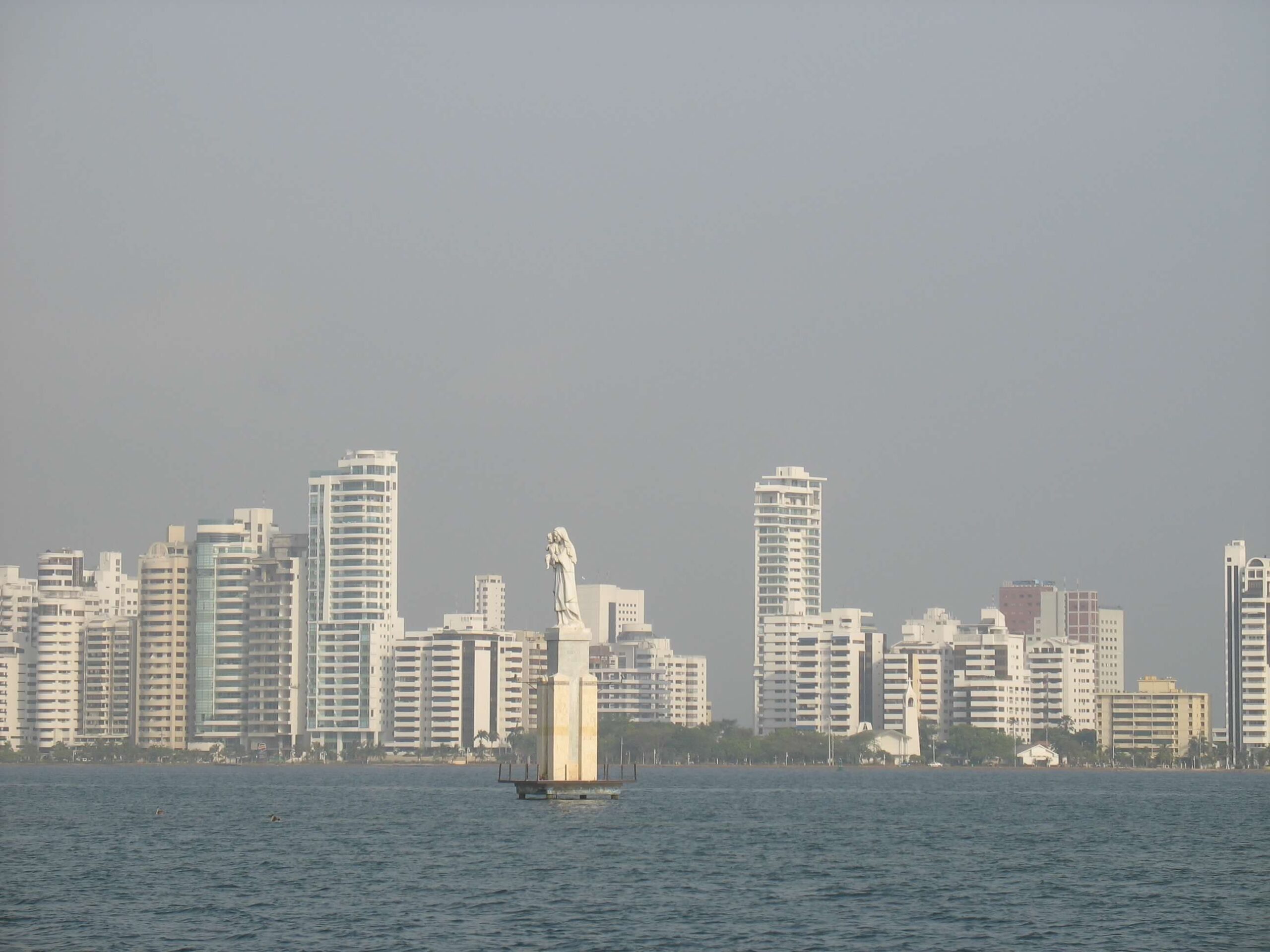
The last leg was 55nm to Cartagena so we left around 6am. It was a motor day and hot but felt blessed for a good passage with no major problems. As we approached, we couldn’t believe that it looked like Miami with all its high rises but reminded of its history as we had to be careful entering the narrow cut of the underwater wall of Boca Grand entrance as this was placed there years ago to protect the city. This wall unfortunately damaged another cruisers boat as the seas pushed them abit and the wall was between the keel and rudder. As we passed the Madonna statue at a distance as not to go aground, we were finally able to see the beautiful historic city.
Be Safe
One response to “Travels from Curacao to Cartagena, Colombia 6-2009”
When will you be sailing to Cartagena, Colombia again? Looking but on leave Cartagena, to travel to Curacao.